Tithe Maps Go Digital

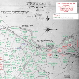
Jacky Heath – a volunteer for the Broad’s Hidden Heritage project – has been interpreting tithe maps of the Halvergate Marshes. Her research has been able to continue at home despite the restrictions imposed during the pandemic. Some of her work has now been digitised by members of Norfolk County Council’s Air Photo Interpretation Team.

Tithe maps were drawn up for almost all rural parishes in Norfolk between 1836 and 1850 as part of a system to determine the level of tax payable for each plot of land. They were accompanied by tithe apportionments which, among other details, give the names for each plot which were usually only identified by a number on the map itself. Using the National Archives’ tithe maps and records available at The Genealogist Jacky has been identifying owners, occupiers, land use and field names.
Jacky has enjoyed the challenge of transcribing from original sources, “I was born to do this” she says. In a recent project newsletter, she explained, “Some of the handwriting is exquisite, ‘copperplate’, others, only decipherable by comparing similar letters on the same page.”
And although many of the field names appear mundane, several have sparked her imagination, “Fiddler’s Close in Acle leads to Merriman’s Green – I could imagine festivities held there. It is now covered by houses, only the name remains.”
“I’ve come across more than one “Dunkirk” – what would the historical reference to this be in the year of our Lord 1840? And why should “Batchelors” get their own field?”

While Jacky’s work continues, members of Norfolk County Council’s Air Photo Interpretation Team have been working to create a digital version of her annotated tithe maps. Primarily covering areas of marsh below the 5m OD contour, the intention is for this digital map to eventually cover all the parishes that Jacky has been working on.

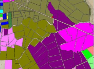
Detailed information – such as the owner, occupier, and state of cultivation of each piece of land – will be attached to a digital representation of the tithe map in a Geographical Information System (GIS). By varying the colours and style of the mapping, it will be easier to see patterns of historical land ownership and use. It will also be much simpler to highlight significant field names, such as ‘Mill Piece’ or ‘Ozier Ground’, which attest to the Broads’ unique landscape history.

The GIS map is being created by using the modern Ordnance Survey digital ‘MasterMap’ mapping. For many areas of the marsh, the field boundaries have changed very little in the 170–184 years since the tithe maps were drawn up. Where changes have taken place – fields being amalgamated, or boundaries altered, for example – the base mapping is altered too.
Each field in the map is assigned a code, based on its parish and the apportionment number (such as ‘TUN_19’). This acts as a link, which allows Jacky’s apportionment information for each field to be associated with the relevant field on the map. The GIS software can then be used to ‘map’ the information, and to highlight different features.


To request more information about volunteering opportunities with the Broads Hidden Heritage project, or to become a subscriber of the project newsletter, please email heritageprojects@norfolk.gov.uk. *Please note this project is due to be completed by 2023 and emails may not be picked up after this date. For further information regarding volunteering opportunities on other heritage projects at Norfolk County Council visit the Historic Environment page here.

